Discover Montenegro's wild side. Step beyond Kotor's city walls and into a world of rugged limestone peaks, remote forests, and ancient fortresses. Whether you're chasing sunrise views or highland solitude, the real magic happens when you put on your hiking boots and venture into the dramatic landscapes that surround this ancient maritime city.
This guide covers the three best hiking trails around Kotor, from scenic ridge walks to wilderness adventures in Lovćen National Park. Each trail includes details, logistics and insider tips to help you make the most of your mountain adventure.
Quick Navigation
Quick Picks: Which Hike is Right for You?
- Best for history + tunnels: Vrmac Ridge – Austro-Hungarian military road with fortress exploration
- Best viewpoint + adventure: Pestingrad Summit – Short, dramatic climb with rope section and 360° panoramas
- Best quiet highlands: Babina Glava Wolf Track – Remote wilderness through ancient forests and mountain meadows
If you'd like the GPX tracks, parking pins, and step-by-step route notes for these hikes, they're included in the Kotor Trail Pack.
Know Before You Go
- Heat & Water: Summer temperatures can exceed 35°C. Carry 2+ liters of water per person and start early.
- Headtorch for Tunnels: Vrmac's fortress tunnels are pitch black. Bring a headlamp or phone light.
- Rope Section Safety: Pestingrad's final approach has a fixed rope. Avoid in wet or icy conditions.
- Lovćen Park Fee: €3 per person for Pestingrad and Babina Glava (collected at park entrance).
- Tell Someone Your Plan: Mobile signal is patchy in the mountains. Share your route and expected return time.
Note: You might notice I haven't included the famous Ladder of Kotor (San Giovanni Fortress trail) in this guide. While popular, I prefer natural mountain trails that offer genuine wilderness experiences, and for me it's not enjoyable to hike up and down hundreds of stone steps when surrounded by big groups of tourists.
Vrmac Ridge Trail – Historic Ridge Walk with Bay Views
Historic ridge walk with panoramic bay views and a hidden fortress.

Trail Overview
The Vrmac Ridge follows the peninsula separating Kotor Bay from Tivat Bay, offering unforgettable views on both sides. This out-and-back route combines stunning coastal panoramas with fascinating military history from the Austro-Hungarian era.
What makes it special:
- Panoramic views of both Kotor and Tivat bays from the same trail
- Historic Austrian fort (Fort Vrmac) with underground tunnels to explore
- Perfect sunrise or sunset hike if you time it right
- Accessible trailhead at Goran's Farm (alternative start from Gornja Lastva near Tivat)
The ridge is just a short drive from Kotor. The trailhead sits beside a small local farm that sells homemade products, and you'll often see pigs and other animals roaming around. Most of the route follows an old Austro-Hungarian military road with sections of uneven stone, so sturdy footwear is essential.
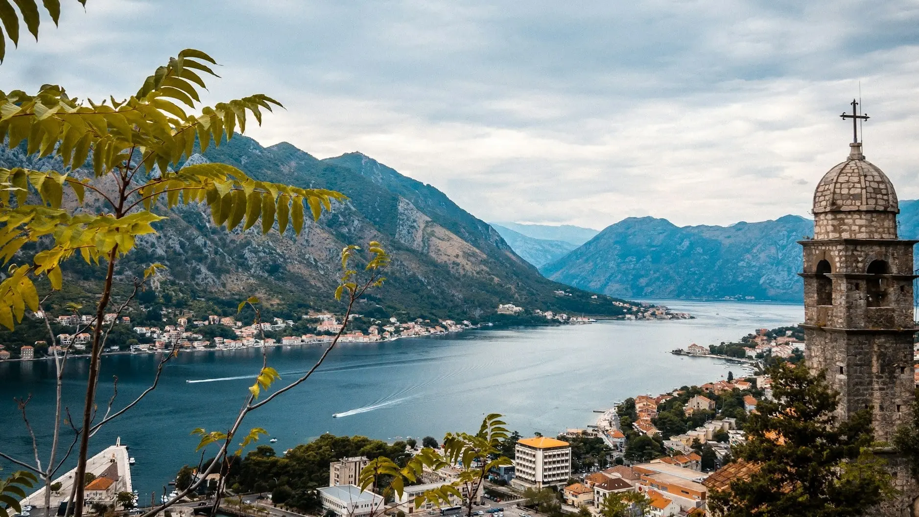
Relics of the Austro-Hungarian era dot the route, and the views from Sveti Ilija (766 m) are breathtaking. The fortress was built to defend against potential naval attacks and contains a fascinating network of underground passages.
Pro Tip: Bring a headlamp to explore the tunnels and rooms within Fort Vrmac safely. The passages are completely dark but well worth the adventure.
Mapped + ready offline in the Kotor Trail Pack
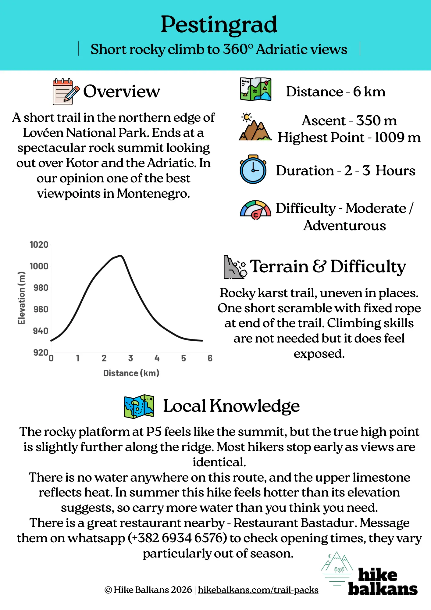
Pestingrad Summit – Hidden Gem in Lovćen National Park
Short, adventurous climb to one of Montenegro's best viewpoints.

Trail Overview
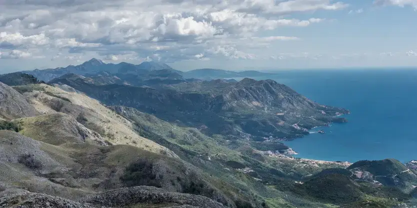
Perched on the northern edge of Lovćen National Park, the Pestingrad Summit Trail offers one of the most striking viewpoints in all of Montenegro. The route combines rugged Dinaric scenery, a touch of adventure, and wide-open panoramas stretching from Kotor Bay all the way to the Adriatic Sea.
What Makes It Special
- Sweeping 360° views of Kotor Bay, the Adriatic coast, and the Lovćen peaks
- Authentic mountain path through pristine karst terrain
- Part of Lovćen National Park, but far quieter than the crowds at the Mausoleum viewpoint
- A true "hidden gem" - few visitors make it here
The hike starts from Etno Selo Sveti Georgije, a charming mountain hamlet with a small restaurant and accommodation. The route begins near the village and soon narrows into a rocky mountain path.
As you climb higher, the views quickly open up across the bay, with Kotor's old town visible far below. The final approach to Pestingrad involves a short section with a fixed rope and light scrambling (somewhat exposed, so avoid if conditions are wet or icy).
Pro Tip: Visit in early morning or late afternoon when the light is softer and the summit's rocky ridges glow gold.
Babina Glava Wolf Track – Wild Highlands Above Kotor
Wild highland route through Lovćen's quietest mountain landscape.
Trail Overview
The Babina Glava Trail leads deep into the heart of Lovćen National Park, involving a sustained climb through pristine mountain terrain, ancient beech forests, and quiet ridgelines with breathtaking views of the Dinaric Alps.
What Makes It Special
- Wide-open 360° views from Babina Glava summit (1,756m)
- Diverse mountain flora, including endemic Balkan species
- Ancient beech and fir forests
- Traditional stone shepherd huts scattered along the route
Locally known as the "Wolf Trail" (Vučija staza), the name reflects the untamed character of these mountains and the presence of wolves in the wider Lovćen ecosystem. While you're unlikely to see wolves themselves, early morning hikers sometimes spot deer, wild boar, or fresh animal tracks along the path.
The trail climbs gradually from the forest into open highland meadows before reaching Babina Glava Peak, where sweeping views stretch from the Adriatic coast to the inland ranges.
Pro Tip: In early morning or late-day light, the summit's rocky ridges glow gold and the forests below turn deep green. Perfect for photos.
Kotor Trail Pack
Everything you need to hike Kotor's mountains independently - built by a local guide.Skip the research and hit the trail with everything you need for safe, independent exploration of Kotor's mountains. Each route has been field-tested and mapped by a local mountain guide.
Designed for independent hikers (not a guided tour booking).
What's Included
- 3 offline GPX navigation files – works without mobile data
- Exact parking coordinates for each trailhead
- PDF guidebook with step-by-step route notes and waypoints
- 3D map video links for visual route preview
- Route-specific safety guidance and terrain notes
- GPX setup support via email if you need help
Prefer company? Guided versions of these hikes are also available.
Frequently Asked Questions
Are these guided hikes or self-guided?
The Kotor Trail Pack is for self-guided hiking. You'll receive offline GPX tracks, detailed route notes, and parking coordinates so you can explore independently. If you prefer a guided experience with a local mountain guide, check out our guided hiking adventures.
Do the GPX files work offline?
Yes. Once you download the GPX files to your phone or GPS device, they work completely offline. No mobile data or internet connection required. This is essential in Montenegro's mountains where signal can be patchy.
Which app should I use for the GPX files?
We recommend Organic Maps (free, works offline, excellent for hiking). It's available on iOS and Android. The Trail Pack includes setup instructions, and we're available via email if you need help getting started.
How difficult are these hikes?
Vrmac Ridge is easy-moderate (suitable for most fitness levels). Pestingrad is moderate-adventurous (includes a short rope section and light scrambling). Babina Glava is moderate (longer distance but steady terrain). All require sturdy hiking boots and basic mountain fitness.
When is the best time to hike? Is there a park fee?
Best months: April-June and September-October (mild temperatures, fewer crowds). Summer (July-August) is hot, so start early. Lovćen National Park charges €3 per person for Pestingrad and Babina Glava trails (collected at park entrance). Vrmac Ridge has no fee.