Kotor Trail Pack
 

Three field-tested day hikes above Kotor Bay with offline GPX, parking coordinates, route descriptions, and practical safety notes.

What You Get

🗺️
GPX Navigation

Field-tested GPX routes for each hike, designed to work fully offline.

📘
PDF Guidebook

A practical guide with maps, logistics, terrain notes, and route-specific safety guidance.

📍
Trailhead & Parking

Exact GPS trailhead and parking coordinates for each route.

Skip the Planning

Avoid route research, navigation guesswork, and local logistics. All essential information is prepared so you can focus on hiking.

Inside the Guidebook

Each route includes step-by-step descriptions, elevation profiles, clear 2D maps, 3D map videos, parking locations, and local condition notes - so you can visualise the route and know what to expect before you start.

Kotor Trail Pack Sample Page 1

Route map - Pestingrad

Kotor Trail Pack Sample Page 2

Safety & local conditions guide

Kotor Trail Pack Sample Page 3

GPX setup guide

The Routes

Designed for independent hikers with basic fitness and comfort on uneven mountain trails.

Twin-Bay Ridgeline

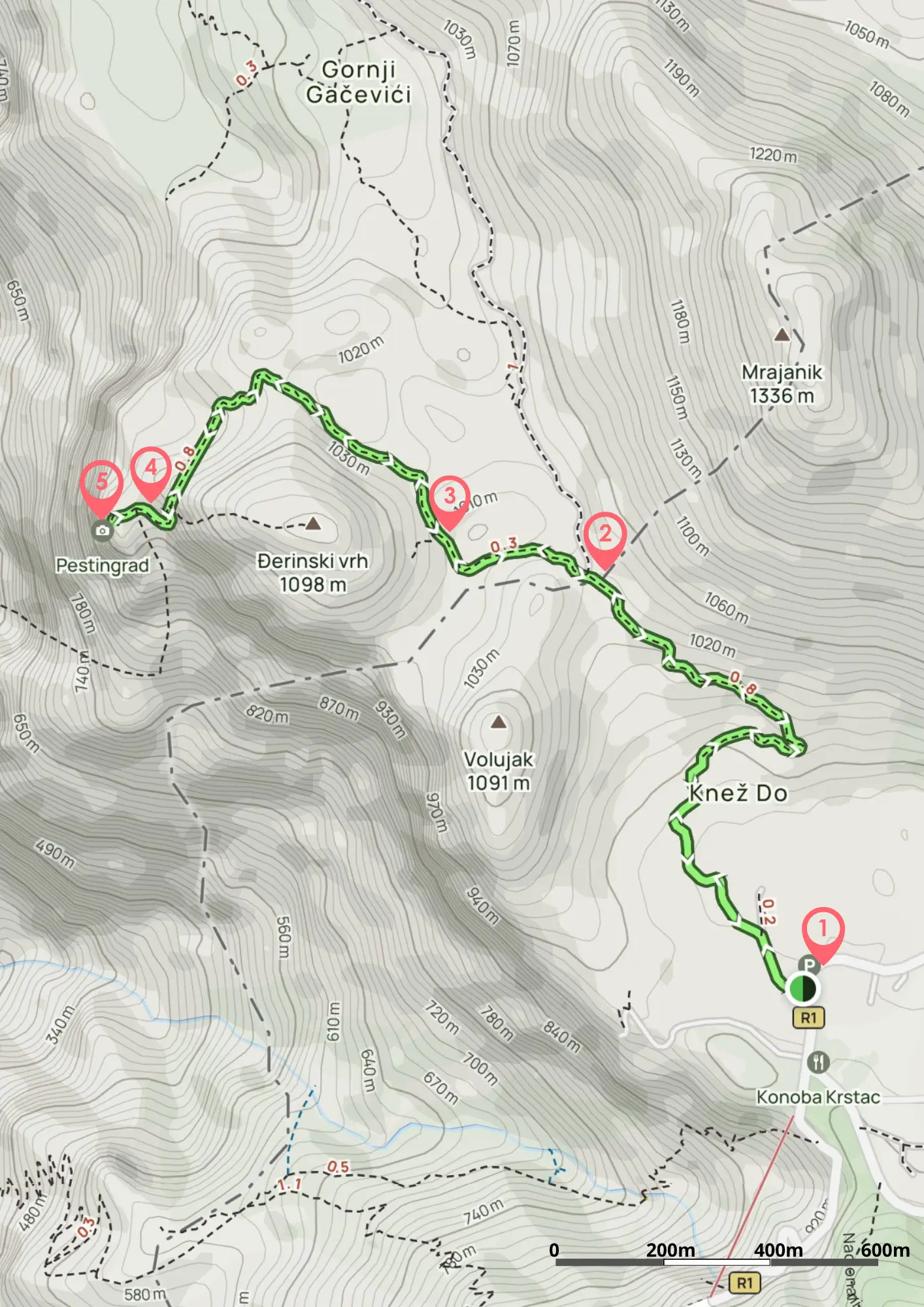
Vrmac Ridge – Twin-Bay Ridgeline Walk

A historic ridge walk between Kotor and Tivat bays, passing Austro-Hungarian fortifications with panoramic coastal views.

Easy–Moderate 9 km 3–4 h
Kotor Sky-Summit

Pestingrad – Kotor Sky-Summit

A short, adventurous limestone summit hike with a fixed rope section and sweeping 360° views of the Bay of Kotor.

Moderate–Adventurous 6 km 2–3 h
Wild Lovćen Highlands

Babina Glava – Wild Lovćen Highlands

A peaceful highland loop through forest and open karst landscapes within Lovćen National Park.

Moderate 11 km 3–4 h

Perfect if you have a few days in Kotor and want to get into the mountains independently.

⭐⭐⭐⭐⭐

"The routes were easy to follow and took us to places we wouldn't have found otherwise."

Pavel, UK

Start Exploring Today

€29

Buy Now →

Instant download after purchase. Files delivered automatically.